New worlds
Jean-Yves Sarazin
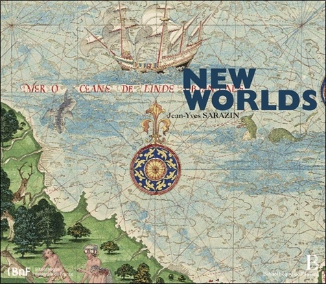
"New Worlds" presents a selection of five outstanding nautical atlases known as portolan charts, or "portalans".These historic documents are the work of eminent scholars from Majorca, Lisbon, Le Havre, and Amsterdam. Cartographers by trade, and sometimes also skilled illuminators, they mapped what was the most probable imago mundi for their time, each exemplar crafting a fascinating visual chronicle. Jean-Yves Sarazin, head of Charts and Maps at the Bibliothèque Nationale de France, scrutinizes thèse charts or atlases, and situates them in the great history of European discoveries and voyages from the early 14th to the late 17th century, from the Portuguese reconnaissance of the coasts of Africa, through the adventures of Columbus,Vespucci, and Magellan, to the Dutch voyages in the Pacific and Australia.The book's many colour reproductions are alive with picturesque details: camel caravans in the heart ofAsia, Portuguese andArab ships sailing in the Indian Ocean, wild beasts or chimaera, countless exotic plants, naval battles, and not least the frequent strangeness of the indigenous people.
17/10/2012
88
pages
10,00
€
Extraits


Commenter ce livre